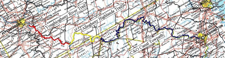
Herein is the tale of my fifth ride on the Youghotomac, the collection of trails that (almost) connect Pittsburgh with Washington, DC. In the past two years, I ended my ride with some question as to whether I would go again the next year. But as the troubles of the previous years faded from memory, plans began anew.
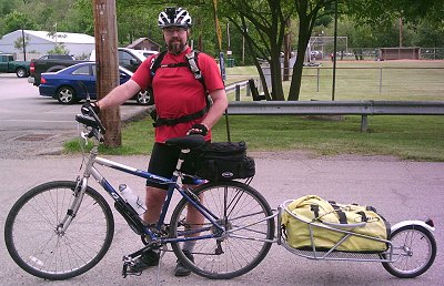
On the Great Allegheny Passage Yahoogroup, I mentioned my probably needing to get a bike trailer. I am at the space limit for my bike and panniers. The problem was that I felt uncomfortable spending $350 for something I would use once or maybe twice a year. I suggested that it would be good if a local retailer or perhaps Bike-Pgh could have a trailer or two for rent. Someone on the list offered to loan me his Yakima Big Tow trailer. Borrowing a trailer would be great but I still had this itch to own.
So, for two months, I bid on B.O.B. Yak trailers on e-Bay. For some, the price went higher than I was willing to go. On at least one I was outbid in the final seconds. But finally I got one for $258.
As my plans developed over the course of the beginning of 2006, the official celebration of the trail opening would be taking place in Meyersdale the Friday of Memorial Day weekend. I made a posting on the Great Allegheny Passage Yahoogroup mailing list that putting the event on a Friday would make it difficult for many (myself included) to take time off of work to participate. After saying that, my calendar settled on having my Youghotomac ride happening that same weekend. As my regular plan was to leave Wednesday night and be picked up on Sunday, I would be riding through Meyersdale on Thursday and would thus miss the festivities.
My wife then learned that friends were going to the Balticon science fiction convention in Baltimore and she decided to attend. The con has programming into Monday so if she was staying for that I could shift my schedule a day to be in Meyersdale on Friday.
Except that my comment and those of others about scheduling parties on Friday got through to organizers and they shifted the celebration to Saturday. I would miss it.
My plan finally settled down to essentially the one I had last year: Leave after work and ride through the night to arrive at Confluence at about 3am. Ride to the Irons Mountain campsite on the C&O on Thursday. To the other side of Williamsport on Friday. For Saturday I would add a side trip to the Antietam Battlefield then ride as far as I could before dark to make for a short day on Sunday into Georgetown.
 Wednesday, 24 May 2006
As soon as the clock reached 4:30, I left work with tremendous haste. I had packed nearly everything the night before so when I got home there were only a few last minute compilations, a quick check of my e-mail, change my shoes and get my daughter to drive me to the trailhead. I was on the move by 6:30.
Most of those who think about the history of the Youghiogheny River Trail and Allegheny Highlands Trail think back a century ago when it was active rail. It's easy when there are still signs of the railroad left behind, telegraph poles, power junctions, tunnels, bridges and trestles, railroad ties, acid mine drainage and even some places where there are still tracks and railroad crossing signs. For me, though, I think even further back. Another 150 years to the French & Indian War when this was the contested frontier and the front lines in a war between two great powers.
Once the trail is fully complete into Pittsburgh itself, it will be starting at Point State Park. In the 1740's, English fur trader William Trent built a trading post there. The British hoped to build a genuine fort in the area in 1754 but were chased off when a larger French force came south to build Fort Duquesne. (The outline of Ft. Duquesne is marked on the lawn near the point fountain.)
In 1755, the British returned in force. At it's last leg, General Edward Braddock's regiments crossed the Monongahela River twice (once from present-day McKeesport very near where the trail will eventually cross and again near the mouth of Turtle Creek below Kennywood) and got themselves severely beaten on July 9th, 1755 where the town that bears his name stands today.
And in 1758, General John Forbes was finally able to dislodge the French from Fort Duquesne. In their withdraw, the French destroyed Fort Duquesne and, in its place, the British built the much larger Fort Pitt. (The last remnants of that are the Blockhouse near the Ft. Pitt Museum and the Music Bastion, but more on that later.)
Hitting the trail that currently exists, the first French & Indian War relevant site you come across is adjacent to Dravo Cemetary. This open field is reported to have been one of several campsites in the area occupied by Seneca Queen Aliquippa. In 1753, a young Lieutenant George Washington had been sent north in an attempt to negotiate with the French to keep them out of the Ohio Valley. Stopping at Frazer's Cabin at the mouth of Turtle Creek, he was informed that Queen Aliquippa was upset that he had not come to visit. Aliquippa was a strong and respected ruler in the area and such a summons could not be ignored. After his less-than-successful negotiations with the French, Washington visited the Queen at her encampment in what is present-day McKeesport.
Six months later, after Washington's disastrous encounter with a French diplomatic mission and the murder of Ensign Joseph Coulon de Villiers de Jumonville, Queen Aliquippa again met with Washington as he prepared his hasty defences of Fort Necessity at the Great Meadows. Washington wished to perform a ceremony honoring the Queen for her service and loyalty to the British cause but the Queen declined, sighting ill health (she was in her 80's). In her stead, her son Kanuksusy accepted the honor.
I don't know if there is any archeology to support the legend that Queen Aliquippa had a camp at Dravo but surely, her influence was in this place, just as it was all over Southwestern Pennsylvania.
 Between Dravo Cemetary and Buena Vista, I saw a couple looking intently at something on the side of the trail. I thought it was a baby weasel but all the descriptions of weasels in Pennsylvania have them as various shades of brown. Then I thought, Holy Potatoes, it was a mink! This one was a silky black from nose to tail. On more thought and investigation, I now believe it to be a Fisher. Fishers are being reintroduced to Pennsylvania and while the older ones are more brown, some pictures of the yound ones look quite black. It was about 9 inches long and didn't run off the trail even with us huge bumbling humans looming over it. Perhaps it was injured or too young to know better. In any case, I never though I'd see such a thing along the trail. I wish I had a better camera than the fixed-focus one I have so that the picture wouldn't be so blurry. On the other hand, the last time I took a camera with auto-focus and optical zoom on one of these rides it didn't survive the trip.
As we stood there admiring the little creature, another biker rolled up on his way to Pittsburgh from DC. He had a BOB trailer like mine but with easily twice the amount of stuff in it than I had. He also had a trunk bag with two or three times as much stuff as mine piled on. Additionally he had a pair of rear panniers, front panniers and a handlebar bag. What all could he be carrying? Even if I took twice as long for my ride, I wouldn't quadruple or quintuple the amount of gear I carried. Hell, when I go to a campsite in my car I didn't carry that much gear.
The rest of the ride was quiet, solitary and uneventful. Normally, when I take these long vacations (and typically four days is a long vacation for me) it takes a full day of monotonous trail and fatigue to drive the negative thoughts of work, life and the so-called real world out of my mind. But on this trip, I forgot fairly quickly. I credit the possibility of my moving to a new position and client site and the likelyhood of a raise for raising my spirits in advance of my trip. So, instead of lamenting the sorry state of my employment, my mind was for the most part filled with a loop-tape of Japanese pop music and the first draft of this blog. "Shizuka ni. . . Deguchi ni tatte. . . Kurayami ni. . . Hikari wo ute. . . "
Just as the trail hits the pavement taking you down into Connellsville, at about mile marker 88, is the ford known as Stewart's Crossing. General Braddock camped near here (his twelfth camp since leaving Cumberland) several days before crossing the Youghiogheny River on June 30th, 1755 on his way to attack Fort Duquesne. Imagine if you will an army of several thousand with baggage and artillery, cutting a road through old-growth forest to reach the forks of the Ohio in a little over a week. There is, of course, nothing to mark this place. The historic marker for Stewart's Crossing is a mile and a half away on Rt.119.
I got into Connellsville at 10:50. I had started at a normal and steady 13mph but as the evening went on my pace was begging to slow. I took this into account in my planning and expected to get into Confluence at 3:00 in the morning. Normally, when one is riding at night, you are focused intently on the little pool of light in front of you and that attentiveness keeps you from getting tired. Perhaps because I've done this a number of times I've gotten comfortable enough to allow my fatigue to have me actually sleepy.
There had been work ongoing on the Ohiopyle High Bridge and the park service had been closing the bridge during the week. At least, that was the official word. If I arrived and found the bridge to be closed I would need to take the Great Gorge Trail for two miles around the Ferncliff loop. I hadn't expected trouble and was right as when I arrived there was no sign of any construction on the bridge and it was clear riding into Ohiopyle at 2:00.
When George Washington came through here in 1754 on his way to reinforce the British Fort Prince George, the barely reinforced trading post of William Trent in present day Pittsburgh, he had hopes of a water route to the Forks of the Ohio. Those hopes were dashed at the Great Falls of Ohiopyle, the river dropping 75 feet through a rock-filled gorge in less than half a mile. Even so, he never gave up. In fact, The Chesapeake and Ohio Canal Company acquired Washington's Potowmack Canal Company in the 1820's with the plan of completing that water route over the Alleghenies. The C&O Canal only made it as far as Cumberland, but Washington's dream was not easily abandoned. The railroads overtook the canal and completed the link that Washington had pressed for a century and a half earlier.
At Ohiopyle, I was tired. Sleepy tired, and still had 11 miles to go. Rather than pressing on I decided to take a short nap on the benches at Ohiopyle Station. In all, I got about 20 minutes of sleep before riding on. Not exactly refreshed but better than I had been. I arrived at Confluence at 3:40, laid out my sleeping bag on a picnic bench and finally got some sleep.
Thursday, 25 May 2006

 Breakfast was an "Inferno"-brand heater meal I picked up at REI. Homestyle Chicken Booyah. First off, what the heck is Booyah? I picture US Marines or Ron Stoppable from the Kim Possible animated show. Actually, Booyah is a thick chicken noodle stew that Belgian immigrants brought with them to Wisconsin. The meal contents seemed reasonable enough but the meal was something less than inferno hot. While the chemical heaters are convenient, I continue to be un-impressed by both the military MRE and civilian versions of these meals.
I hit the trail at 8:30 just as it was beginning to rain. The Allegheny Highlands Trail (and the Yough Trail, too) are wonderfully even and smooth. But when they get west, they get uniformly soft and the tires sink in a little more, slowing one down. In addition, the trail begins to get steeper as it travels south. My pace never recovered from the end of the previous night. Even though the rain stopped around noon and the trail began to dry out, it took me until 3:00 to get to Meyersdale. 30 miles in 6 hours. Awful. I should be able to do that in half the time. I blamed the rain softening the trail and the weeks of rain before the ride that kept me from doing training rides, instead relying only on my commute.
In years of riding the trail, this was the first time I was in Meyersdale when the station museum was open. Staff was there preparing for the big celebration that was to happen Saturday. I spent 20 minutes taking a look around and downing a cold Gatoraide from the vending machine before hitting the trail again.
Somewhere around Sand Patch, I saw a large bird of prey. I only caught a glimpse of it before it soared behind some trees but I though sure I saw a flash of brilliant white at the head. A bald eagle? Is that cool, or what? I've seen bald eagles before but never in southwestern Pennsylvania.
Approaching Big Savage tunnel, I could feel the cold wind pouring out of the portal, like a frigid rocket. That dramatic change in temperature and the damage that icing could do to the multi-million dollar lining of the tunnel explain why they close the tunnel between Thanksgiving and April. It's too bad they couldn't come up with a way to allow passage throughout the winter. I imagine a normal person-sized door set in the larger gates with strong springs on them to make sure they closed when people passed. Otherwise, it's an 11 mile on-road slog up and over Big Savage Mountain to get between Deal and Frostburg. I've done that a number of times and it's no fun. It's a shame that the Great Allegheny Passage is effectively closed 5 months out of the year.
I exited the south portal of Big Savage Tunnel at 5:20, determined to make up for lost time. 21 miles to Cumberland. It was 15-20mph for most of the way down Big Savage, Up to 30mph for the last mile into Frostburg. I had my bike up to nearly 40mph on portions of Woodcock Hollow Road and made Cumberland at 7:00. Last year, I started out from Confluence an hour later and arrived in Cumberland an hour earlier but the way I felt riding between Frostburg and Woodcock hollow reinforced my belief that most of my delays were caused by the soft, wet trail in the morning.
The Confluence to Cumberland section is the toughest of the entire trip, not only because of the climbing of Big Savage but also because it cannot be broken up. If I wanted to take an extra day to do the whole trip, I would still have to do the Allegheny Highlands Trail in one day because the 63 mile section of trail has no campsites along the way. And while this is difficult for someone on a bike, it is impossible for someone hiking. A hiker would be forced to either leave the trail to find a hotel or Bed & Breakfast or camp along the trailside in an unauthorized location.
The Youghiogheny River Trail now has three free hiker/biker campsites along the way (Dravo Cemetary, Cedar Creek and Roundbottom) plus the Outflow Campground at Confluence (which has a nominal $4 fee that I haven't paid because I'm always arrived after midnight). That's an average of one campsite for every 17 miles. The C&O has 29 hiker/biker camps and, even if you exclude the half dozen drive-in sites that may have a camping fee (or I avoid because they are often crowded), that's still one campsite every 6 miles or so. The Allegheny Highlands Trail has one campsite, and that's the Confluence camp at it's northern end. I would advise the trail developers to seriously look into getting at least two campsites along the trail. One between Rockwood and Garrett and another near the Big Savage Tunnel. This would allow more hikers to use the trail and allow cyclists to more evenly divide up their daily mileage.
Biking in May rather than September meant that even though I had arrived in Cumberland an hour later, I still had more daylight to available to get to the Iron's Mountain campsite. I cleaned up in the Wendy's restaurant restroom, refilled my water supply and got something to eat. A half hour later, I was just about to get back on the trail when I was approached by a curious cyclist. He was looking for a safe place to park his car for a few days so he could ride down to Harper's Ferry. There's a free lot off of Howard Street beneath the Rt.40 overpass but I'm sure it was "park at your own risk" and, not being from around here, I couldn't speak to the safety of leaving one's vehicle there overnight. I warned him about the railyard noise of the Evitt's Creek campsite and recommended where I was headed for, Iron's Mountain, even though rail goes by that camp, too. I think that rather than riding the 9 miles to get to that camp, he decided to sleep in his car and leave in the morning.
I notice that where the end of the C&O passes by the barge "The Cumberland" and crosses the canal, they have reconstructed and watered the canal. It seems very neat and clean and, knowing what watered sections look like further down, artificial.
 I pulled into the Iron's Mountain campsite at 9:00 just as it got dark enough that I needed to use a flashlight to put up my tent. I'd gotten a new Eureka Spitfire to replace the coffin-sized Eureka Solitaire I had been using. It's a little heavier and doesn't pack quite as small but it is tall enough to sit up in. I had also borrowed the Therm-a-rest ProLite 4 sleeping pad I had bought for my wife. These two additional pieces of equipment were what sent me over the top for space and prompted me to upgrade from panniers to a B.O.B. Yak Trailer and it was so worth it. The Spitfire is so much easier to get into and out of and, being more roomy, doesn't get anywhere near as hot when the rainfly is on. The ProLite 4 solved all my problems with tossing, turning and my arms going numb sleeping on the hard ground. Aside from the passage of two trains, I slept through the night.
Friday, 26 May 2006
In fact, I slept so comfortably that I woke up before 5:30 when my alarm was set to go off and didn't roll over in an effort to get more sleep. I pulled the tab on the heater meal to start the chemical re-heating, washed off the previous day's grime, packed up camp and ate. All told, it took me an hour and a half from getting up to hitting the trail.
And then it started to rain again.
It rained most of the morning and again it affected my pace. Not as badly as the day before but still not great. On the plus side, it looks as if the National Park Service has been busy since last year as many of the most egregious puddles have been filled in. It's still nowhere near the smoothness of the Yough Trail but this is the best I've seen the C&O in seven years of riding.
I missed the turn to get on the paved Western Maryland Rail Trail at Lock 56 so I stayed on the towpath until Hancock, arriving there at 2:45. The Maryland Department of Transportation and DNR have obtained the $5 million necessary to extend the WMRT 4.5 miles further west through the 4,350 foot Indigo Tunnel to Little Orleans.
At C&O Bicycle I stopped for some Gatoraide and saw a book that I had been looking to buy. Biking Ohio's Rail-Trails. I've been looking for long-distance rides to expand into beyond the Great Allegheny Passage and C&O and Ohio has the 72 mile Little Miami Scenic Trail and the incomplete Ohio & Erie Canal Towpath. Looking in the book I see that the state has plans for connecting both corridors to make the 335 mile Ohio to Erie Trail connecting Cincinnati with Cleveland. Right now, about half of that corridor is complete but that will be an impressive rival to the Youghotomac when it's done. Or rather, a compliment, because the Panhandle Trail reaches towards Dover, OH, the southern end of the Ohio & Erie Canal and the Armstrong and Allegheny River Trails reach north from Pittsburgh to the lake.
Leaving Hancock proper, I noticed a sign for The Druid's Oak, a store dedicated to French & Indian War reenactor clothing. I just had to stop. In speaking with the proprietress, I learned that Fort Frederick was celebrating its 250 anniversary this weekend and there was going to be an event there. I had stopped at Fort Frederick several times in the past but almost always when it was closed. I figured I would stop by and see what was going on.
On leaving the store, this man came shambling up the street saying "Thank you, Jesus." It was odd in that I got the distinct impression that he was not merely thanking Jesus but that he was somehow trying to get me to agree with him in some way for thanking Jesus. He said this twice as I turned my bike around and walked it up to the alleyway. He shambled a little further (yes, he walked with a shuffle or shambling gait) as I mounted my bike and again directed himself at me in an effort to get me to thank Jesus for something. It was a bit surreal.
Seeing the Hardee's across Rt.144 from the trail, I decided to stop there for something to eat. As I prepared to leave, some other diners asked me about my ride. I've gotten used to the biking gear and trailer on my bike attracting questions about where I started and where I was going. I mentioned that I was probably going to be stopping at Fort Frederick because I had heard of the anniversary celebrations and wanted to see what it was about before moving on. They said they were going to be going there as well and I thought I might see them there, although it would take me an hour to get there.
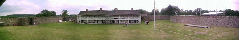
As always, riding on the pavement of the Western Maryland Rail Trail was a nice change from the towpath and I got to Fort Frederick at around 5:00. I spoke with the guard at the gate and he gave me some of the history of the fort. Begun in 1756 early in the French & Indian War, it is unique for its stone construction. Most forts of the period were of wood timbers with earthen ramparts. But with the taking of Fort Duquesne by General John Forbes in 1758 and the shifting of the war even further north, funding for the construction at Fort Frederick was cut. The Officer's Barracks, called the "Governor's House," was never completed and the outer ramparts showed no signs of having even been started. The fort continued as a staging point for patrols during Pontiac's Uprising, a prison during the Revolutionary War and an outpost for Union soldiers during the Civil War. After that, the land became farmland, to be purchased by the State in 1922 to become Maryland's first State Park. The Civilian Conservation Corps refurbished the fort in the 30's and the two barracks were re-constructed in the 70's. Plans are in the the works to reconstruct the "Governor's House" upon the (almost) original foundations.
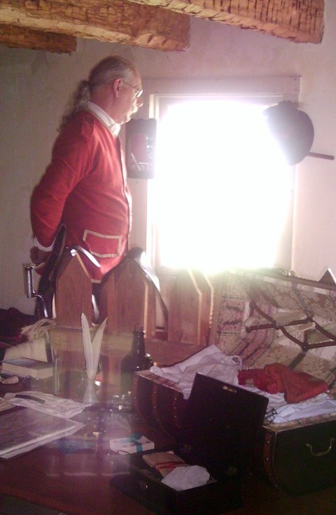 It turns out that the people I had talked to at the Hardee's in Hancock had arrived at Fort Frederick ahead of me and had gotten into costume. If I remember the logo on their shirts at the Hardee's correctly, they were members of the 77th Regiment of Foote, a highland regiment of recreationists from the Ohio/Indiana/Kentucky area. They showed me around the barracks, noted the specifics of equipment and uniforms and we talked about the French & Indian War. Mostly, that conversation was about how little people know about this war. I recall almost nothing in elementary school about the period in history between the Pilgrims and the Revolutionary War other than a mention or two.
I mentioned to them that for Pittsburgh's 250 anniversary the City plans to bury the Music Bastion. Right at what will be the northern terminus of the Great Allegheny Passage is Point State Park, once the site of Fort Pitt. Just before the place where there overpasses connecting the Fort Pitt and Fort Duquesne Bridges cut across the park there is an arrow-shaped ditch with is a reconstruction of one of Fort Pitt's outer ramparts. And for 40 years, the city has pretty much hated it. They look on the ditch as a hindrance to a more effective use of the land for concerts and public gatherings. Since so very little of the original fortification wall exists, they look at it as having no inherent historical value and plan on filling it in.
Two and a half centuries ago, a world war was fought in our own front yards. The names of people who fought that war are noted all over Pittsburgh; Forbes, Grant, Braddock, Duquesne and even the name of Pittsburgh itself is in honor of William Pitt, the British Prime Minister who lead the war against the French. Fort Frederick is celebrating it's 250th anniversary by breaking ground on a $2.3 million reconstruction of the fort's officer's quarters. Pittsburgh is celebrating its 250th birthday by burying its past.
Wanting to get to the Cumberland Valley camp before dark, I had allocated an hour at Fort Frederick before having to move on. Most of that was spent talking with these guys and as 6:00 was the scheduled time for the artillery demonstration, I decided to stick around until at least then. That happened 15 minutes later and, having stayed longer that I felt I should, I set off as if the cannot were a starter's gun.
I pulled into the Cumberland Valley camp with enough daylight to set up camp and clean up. I noticed that I felt in better shape on this section than I had for the bulk of the day and have come to the conclusion that it's because those heater meals just aren't enough food.
Saturday, 27 May 2006
Have I mentioned how great the Therm-a-Rest ProLite 4 is for sleeping? If the Great Allegheny Passage is linked to the French & Indian War, then the C&O Canal is connected to the Civil War. The Potomac River was the border between the Union and the Confederacy and this border was fought over regularly during the course of the war. Between Fort Frederick and Williamsport is a transition of a century and continuing south brings historic markers and more familiar names.
My Saturday was going to be dominated by a trip to the Antietem Battlefield, starting with my leaving the towpath at Snyder's Landing and riding up the hill towards Sharpsburg. As I got into town itself I saw the distinctive signs of preparation for a parade. The flags and banners lining the streets, the armed Confederate soldiers walking down the sidewalks, the folding chairs in the streets staking out prime parade-viewing locations.
But even in Sharpsburg, I could not put the entirety of the French & Indian War behind me. On the main street in front of the Library was a plaque commemorating that in April of 1755, after ten days of meeting with Benjaman Franklin in Frederick to prepare for his Fort Duquesne expedition, General Braddock crossed the Potomac River into Virginia. Braddock was merely passing through Sharpsburg.
Sharpsburg wasn't really a destination for Robert E. Lee, either. The Army of Virginia had crossed the Potomac in September 4th 1862 to take the fight to the Union. The war was at a turning point and, if the Confederacy was going to get support from potential allies France and Britain, they needed to demonstrate that the war could be won. Lee's had ambitions of taking Harrisburg.
Things didn't work out as planned. General "Stonewall" Jackson's siege of Harper's Ferry took longer than anticipated and the Union was unexpectedly aggressive. Unbeknownst to Lee, Union General George McClellan had come into possession of a copy of Lee's battle plan and thought he knew the location of all Lee's forces. But, true to form, McClellan hesitated, always looking for the perfect endgame with overwhelming forces. This delay allowed Lee to consolidate his forces and fall back to a battleground of his choosing; the fields just west of the Antietam Creek.
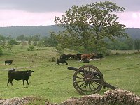 The road out of Sharpsburg towards the Visitors Center has a wide berm and was an easy ride. One would think it to be typical farmland were it not for the roadside historical markers and the cannons in the cow fields. At the Visitors Center I picked up a battlefield tour map and paid my $4 admission fee. I could have simply kept riding my bike past the center and not paid but I feel that our National Parks could use the support. In the gift shop, map geek that I am I bought an Antietam Battlefield map, a Potomac Campaign map and a map for the Gettysburg Battlefield (I was going to visit Gettysburg in June). I made a quick tour of the museum and set out on my tour.
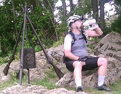
![]() At the 125th PA Regiment Monument.
At the 125th PA Regiment Monument.
The tour is laid out with signs and numbered arrows that start by taking one north to "The Cornfield," where the battle started on September 17th, 1862. At dawn, Union General Joseph Hooker's artillery began a murderous fire on Jackson's men in the Miller cornfield north of Sharpsburg. Hooker's men advanced across the field to be met with heavy resistance. About 7 a.m. Jackson was reinforced and succeeded in driving the Federals back. An hour later Union troops under Gen. Joseph Mansfield counterattacked and by 9 o'clock had regained some of the lost ground. Then, in an effort to extricate some of Mansfield's men from their isolated position near the Dunker Church, Gen. John Sedgwick's division of Edwin V. Sumner's corps advanced into the West Woods. There Confederate troops struck Sedgwick's men on both flanks, inflicting appalling casualties.
For the morning phase, the Union had 22,400 troops engaged to the Confederate's 20,800. Casualties (total of dead, wounded and missing) were also comparable; 6,550 for the Union and 6,050 for the Confederates. In just the morning action at the Battle of Antietam there were more casualties than for the entire Revolutionary War. The Cornfield remains the bloodiest square mile in American history.
 Lunch at the south end of The Cornfield. Gaitoraide and beef jerkey. Yum. The monument is for the 90th Penna. Infantry. |
While the battle was ongoing in the cornfield, Gen. William H. French's division of Sumner's corps moved up to support Sedgwick but veered south into Confederates under Gen. D. H. Hill posted along an old sunken road separating the Roulette and Piper farms. For nearly 4 hours, from 9:30 a.m. to 1 p.m., bitter fighting raged along this road (afterwards known as Bloody Lane) as French, supported by Gen. Israel B. Richardson's division, also of Sumner's corps, sought to drive the Southerners back. Confusion and sheer exhaustion finally ended the battle here and in the northern part of the field generally.
There were 9,700 Union troops engaging 6,500 Confederates at the Bloody Lane. Casualties for each side were nearly a third of total forces engaged; 2,900 for the Union and 2,600 for the Confederates.
 Again, standing on the battlefield, the superiority of the Confederate position is obvious. Advancing Federals would appear over the crest of the hill, silhouetted against the sky and perfect targets, while the defending Confederates would be well protected behind a fence and sunken road. That is, until the Union forces were able to flank the Confederate line and were on the hill shooting down the length of the road. At that point, the road became a murder pit from which there was no escape.
Southeast of town, Union General Ambrose E. Burnside's troops had been trying to cross a bridge over Antietam Creek since 9:30 a.m. Some 400 Georgians had driven them back each time. At 1 p.m. the Federals finally crossed the bridge (now known as Burnside Bridge) and, after a 2-hour delay to reform their lines, advanced up the slope beyond. By late afternoon they had driven the Georgians back almost to Sharpsburg, threatening to cut off the line of retreat for Lee's decimated Confederates. Then about 4 p.m. Gen. A. P. Hill's division, left behind by Jackson at Harpers Ferry to salvage the captured Federal property, arrived on the field and immediately entered the fight. Burnside's troops were driven back to the heights near the bridge they had earlier taken.
Standing on the Federal side of the bridge, one looks up the hill to the dominating Confederate positions. Who in their right mind would want to attack across this bridge? In truth, the Federals spent the morning looking for Snavely's Ford less than a mile south along Antietem Creek. From there, they would be able to outflank the Confederate heights. This effort took too long and Burnside decided to go across the bridge. I don't remember the quote exactly but one soldier thought it would have been just as well to go straight across the Antietem Creek rather than fighting across the narrows of the bridge. The creek, while broad, is only a foot or so deep and an attack across a broad front might have had more success than coming across the choke point of the bridge.
More Americans were killed or wounded at Antietam on September 17, 1862, than on any other single day in history. Federal losses were 12,410, Confederate losses 10,700. Looking at those numbers, one might mistakenly believe that this should have been a Confederate win but at the end of the day, all of Lee's forces had been hotly engaged while McClellan still had an entire corps in reserve. Had he pressed his advantage the next day, McClellan might have utterly destroyed the Army of Virginia and ended the war. He hesitated and allowed Lee to escape. The damage was done, however. Lee's inability to achieve his goals lead Great Brittan and France to withhold their aid. If the war was to be won, the Confederacy would have to win it on their own and, less than a year later, Lee would try once more to take the war to the enemy. This time driving into Pennsylvania to a little crossroads known as Gettysburg.
And while this was not a decisive win for the Union, it was enough for President Lincoln to pull a draft document that had been sitting in his desk and, on January 1, 1863 issue the Emancipation Proclamation.
I returned to the C&O towpath by way of Harpers Ferry Road down to the Antietem campground four and a half hours after leaving for my tour of the battlefield. I had gotten a book out of the library about the battle in the weeks before my trip so I had a sense of how things panned out but I still think it would have been nice to have rented the CD to hear the battle narrated as I went along the tour route. In June when my family and I visit Gettysburg we'll either do the self tour with a CD or go with an official guide. I'm tendant towards the CD for the lower price and added flexibility of going at our own pace.
I arrived at Brunswick at 3:20 and decided that I wanted to get something to eat. Coming up from the trail I saw a family diner that had closed after lunch time and a chinese restaurant that hadn't yet opened for dinner. I turned right in hopes of finding someplace with food, skipped the bar and was unsuccessful. I recall having done just this futile search before but there was a geocache in a small park out that way and figured I'd log that while I was in the area. It didn't take very long to find it as an all-too-common form of microcache.
Back into town, I saw some bicyclists clustered outside the Brunswick Railroad Museum and C&O Canal National Historic Park Visitor Center and asked there about a restaurant. I was directed up the block. Before going there I bought two books from the Images of America series; Along the Baltimore & Ohio Railroad and The Chesapeake and Ohio Canal. Typically, on one of these trips I would not expect to come home with more stuff than when I left. I spent over $75 that weekend on books and maps. I still had some money with which to feed myself, though.
Beans in the Belfry is a cafe in a converted church. They describe themselves as having an "eclectic menu" which typically means tendant towards the vegetarian side of the spectrum. As a meatatarian, I had trouble satisfying my more carnivorous tastes and settled on a Tuscan Panini "with no vegetables" and a bottomless glass of iced tea. When they brought the sandwich, they said it had no vegetables but then admitted that it had some. Apparently, when one says "no vegetables" they hear "no onions" and leave the tomatoes and leaf spinach on the sandwich. It was pretty good after I picked the offending vegetable matter off. To get back at them I literally emptied the sugar container. I like my tea very sweet.
I spent nearly two hours in Brunswick. As I was at the parking lot looking to see if I could find a USGS benchmark along the tracks there, a guy pulled up in his SUV asking if it would be OK to park in the lot overnight. He was looking to do some bike riding and camp overnight. I told him that I had started in Pittsburgh so I didn't know the vagarities of this lot but suspected that people used it for just that purpose all the time. He decided to just park and asked if I hand a minute to talk. He wanted to know about the Great Allegheny Passage, how much of it had been completed, what the trail conditions were like. I filled him in on all the details and gave him one of my extra trail maps.
My goal for the day had been to get as far as the Marble Quarry campsite but with all the time at Antietam and in Brunswick I thought I might not make it that far. But a good meal gave me the energy I needed to make good time and get to Marble Quarry with enough daylight that I considered riding on to Turtle Run. In the end, I decided to just make camp where I was.
I noticed a strange thing on this trip. My left knee hurt when I was riding but my right knee hurt when I was lying down and trying to sleep. I still haven't been able to figure out just what's up with that.
Sunday, 28 May 2006
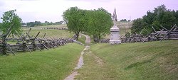
For the past two years I haven't ridden the last 30 miles of the trail. Last year I crossed at White's Ferry to ride the Washington & Old Dominion Trail and the year before I ran out of time and only got as far as Edward's Ferry. It was nice to ride some of the sections that I have been missing out on. Most notably, the Widewater below Great Falls. In years past, one had to haul ones bike up the stairs and across the stop gate above Lock 16 and ride the detour along the Washington Aqueduct. One could walk along the "towpath" but it was a rocky trail unsuitable for biking. (I know, I did that in 1999.) The Park Service has finally completed refurbishing this section of trail and it is exceptional. Widewater is very nice and seeing it from the towpath level is worth the additional pedestrian traffic.
Trail users are different at the southern end of the trail. In the north, nearly everyone you pass, whether jogging, walking or on a bike, will say "good morning" or some other greeting. If you pull over for a snack or a break, riders going by will ask if you're ok. It seems as if trail users are part of a single community. That this is "our trail." But in the south, I see attitudes change. The greetings are gone. People stare straight ahead, refusing to make eye contact. iPods isolate people from each other. People are less willing to move over to let someone pass by. Instead of it being "our trail" it becomes "my trail".
This isn't some Mason-Dixon line thing, or even a different between Pittsburgh and Washington. I think it is more a matter of population. The more people there are, the less they interact with those around them. They become insulated by sheer numbers. I'm not a terribly social person but I do "tip my hat" to riders as they pass by and my trailer seems to begin a lot of conversations. But getting close to the city, I don't enjoy the crowd or need people literally cursing at me because I dare to pass them without signaling with a bell (I needed both my hands to steer my bike through the heavy traffic.) Is it any wonder I prefer riding alone.
I was hungry and still had plenty of time before my wife was to meet me in Georgetown so I stopped at Fletcher's Boathouse and had a $3 hotdog. Actually, it was a typical $1.39 a pound hotdog for which I submitted to a usurious 2000% markup. Welcome to our nation's capital.
 Part of my initial plan was that if I had extra time I would ride the Capital Crescent Trail to Bethesda and then come back on the Rock Creek Trail. I did probably have that much time but I was tired from being on the trail for four days and decided to just continue on into Georgetown and wait. I had some books I could read in the meantime and loitered in the park on the Georgetown-side of the Key Bridge.
After several hours, I got the cell phone call that Heidi was approaching and I went to stand where she could pull over and pick me up without having to find a place to park. I ended up standing in front of the Ukranian Embassy for 15 minutes before she finally showed up. I threw everything into the car, put the bike on the rack and then it took us half an hour to get turned around, across the Key Bridge and the hell out of town.
![]() In front of the Ukranian Embassy.
In front of the Ukranian Embassy.
Epilogue
Heidi now officially hates meeting me in Georgetown. The worst part being, I suppose, traversing the eternally gridlocked Key Bridge. So, the solution for next year is that I will jump onto the Capital Crescent Trail and meet her in Bethesda or Silver Spring to be picked up if she's in Baltimore for the con (and I do the ride Memorial Day weekend). If she's staying with my sister in Frederick then I'll ride out the Rock Creek Trail and meet her near Gaithersburg.
One of the last things I did before leaving was to step on the scale. I weighed in at 220 pounds. When I returned, my weight had dropped to 214 pounds. In all honestly, I'd like my weight to be down closer to 200 pounds but the Youghatomac ride is not the time to try to loose weight. Given that I'm probably burning around 3,000 calories a day during my ride, the 300 calories in one of those heater meals at breakfast just isn't enough. The double cheeseburger, fries and softdrink that I had at Hancock Friday afternoon weighed in at around 1,100 calories and is probably the kind of intake I should have to sustain me. It's a bit absurd to carry four times the number of heater meals to get the caloric intake so I'll need to find some alternative.
One alternative I'm considering is trading up to a stove and dehydrated meals. Because the meals are dehydrated, I wouldn't be carrying the water all the way. And even the meals plus the stove turn out to weigh less than the heater meals. I like the Jet Boil a lot. It's compact for hiking/biking and is highly rated.
But looking at various brands of dehydrated food I find that the single serving meals tend to average 340 calories . That's not much better than the heater meals. And even getting the two-serving size doesn't get me up to the 1,000 calories I should be putting down two or three times a day. I need to find more calories. The towns I've been stopping in along the way (Cumberland, Hancock, Brunswick) will do for a midday meal or dinner but I need more calories for breakfast. I believe that would go a long way towards solving my dropping pace problems. A full-size Snickers bar weighs in at 280 calories. Maybe I just need to pack more of those.
While I like riding at night, I'm liking it less and less. It probably has much to do with it being the end of a very long, hard day, what with spending a full day at work and then riding my bike 70 miles. Next year I think I'll take half a day off on Wednesday which should allow me to be on the trail at least 4 hours earlier. Getting into Confluence at 11pm would get me a good night's sleep for the climb over Big Savage.
Next year, the Bollman bridge on the other side of Meyersdale will span Scratch Hill Road. The nine miles between Woodcock Hollow and Cumberland, including the Brush Tunnel, will be complete. And, except for the Slackwater Detour on the C&O (which looks to be in place for many years to come) the trail will be complete between Mckeesport and DC. Hoody-hoo!
[Return to Kordite's BikeBlog]
[1999]
[2003]
[2004]
[2005]
[2006]
[2007]
[2009]
| http://www.tasigh.org/gps/gap2006.html -- Revised: 25 July 2006 Copyright © 2006 Kevin A. Geiselman |